


Pointe de Beauregard

i20
User
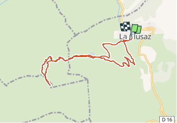

Length
10 km

Max alt
1631 m

Uphill gradient
598 m
Km-Effort
18 km

Min alt
1029 m

Downhill gradient
605 m
Boucle
Yes
Creation date :
2020-03-06 09:34:37.771
Updated on :
2020-03-06 14:13:12.079
4h37
Difficulty : Very easy

FREE GPS app for hiking
 SityTrail
IGN / Geographical institutes
SityTrail Plus
The world is yours!
About
Trail Touring skiing of 10 km to be discovered at Auvergne-Rhône-Alpes, Upper Savoy, La Clusaz. This trail is proposed by i20.
Positioning
Country:
France
Region :
Auvergne-Rhône-Alpes
Department/Province :
Upper Savoy
Municipality :
La Clusaz
Location:
Unknown
Start:(Dec)
Start:(UTM)
300027 ; 5086543 (32T) N.
Comments